Wednesday, August 15, 2012

Lava Beds National Monument and Vicinity

August 9th and 10th

We left Klamath Falls, Oregon, and drove south into northern California.  We had done some research to see what might be interesting to visit on our way south, and came up with Lava Beds National Monument.  Lava Beds is located just over the border into California.  Its lies on the flank of a massive volcano called Medicine Lake.  There are several different types of volcanoes.  The one we usually think of, the pointy-topped mountain, is called a composite volcano.  Medicine Lake is a shield volcano which, as its name suggests, is flat-topped, not very high, but covers a lot of territory.  They are created with multiple cinder cones, lava tubes and spatter cones.  It is considered dormant, but the last eruption was less than 1100 years ago, so activity is likely again.

As we drove into the park, we passed by Tule Lake, which is a wildlife refuge.  It was swarming with birds of all types, many of which we were not familiar with.  One was interesting- it was black with a gold head and chest, and with some research, we determined he was a yellow-headed black bird.  Really pretty. Another great bird sighting was of white pelicans- at least 30 birds in several groups, patrolling the area.  We could see Mt. Shasta off in the distance, looking spooky with its base obscured by smoke.   An interesting fact about Tule Lake- it used to be a lot larger, but the government decided to drain it to create more fertile land in the area.  The fertile land was then given to veterans after WW I and WWII to farm.  OK, that idea is nice, but.... let me see, draining a lake in the desert to create land to farm... seems a little short-sighted to me.  After all, the water is needed for farming, and you have now made that vital resource smaller!

Another interesting piece of history is related to the Medoc Indians, who inhabited this area for centuries prior to the westward migration.  There are thousands of carved petroglyphs and painted pictographs, many of which have been protected.  Most are located on a cliff called Petroglyph Point, a high cliff used by many birds including cliff swallows, hawks, and peregrine falcons.  It is used as a winter home by hundreds of bald eagles.  You could tell which ledges, nooks and crannies were used by the birds by the white guano staining the stone.  The number of petroglyphs was incredible.  It was difficult in some areas, however, to determine when some may have been added at a later date.  The area is protected with fencing now.

The Indians used this lava rock-strewn area as a fortress during the Modoc wars, when the U.S. Army was called in to protect settlers in the area.  The Medocs were asked to give up their homeland to live on a reservation.  They did so, but left when tensions rose due to limited resources.  The Army was told to return them to the reservation by force if needed.  In their fortress, the Modocs were able to hold off the army for nearly 5 months.  Peace negotiations failed, and the band of Indians was captured.  The leader, known as Captain Jack, and three others were hanged.  The families were sent to Oklahoma and never saw their homeland again.

Lava Beds also has a large number of caves and lava tubes that can be toured.  The caves are habitat for 14 species of bats.  We again chose not to tour these caves.  They were requiring hard hats (sold at the Visitor Center), flashlights, and hard-soled shoes.  They were also providing education on the white nose fungus we learned about at Mammoth Caves.

Blazing Star

Edge of the lava field

Lava bed

Headwall of lava

Lava rock with new growth

Moon over lava

Distant view of snow-capped Mt. Shasta

Petroglyph Point

Petroglyphs

Yellow-headed black bird
This was an interesting park, and if you are in the area, certainly worth a visit.

We decided to find a small town to stay for a few days, basing our choice on the presence of a golf course.  We found a town just southwest of the monument called Alturas.  They had a nine hole course, relatively flat.  We checked it out on our way into town, and decided to play the next day.  By the next morning, we decided one night here was enough- the town was just too small with not much going on, and not much nearby to do.  We walked nine holes on Friday morning before we left town.  We had the pleasure of seeing Mule deer on the course, one of whom spent his entire morning sleeping in the shade of a tree right next to the 8th tee.  The players didn't concern him in the least!  It was a pretty basic course, the folks were really nice, so overall a good experience.  Needing somewhere with more to do, we decided to head back to Nevada to Carson City for a few days.

Tuesday, August 14, 2012

Crater Lake- Addendum

August 8th

I had another story about Crater Lake I wanted to include in the blog, but ran out of time last night.  This is another great Mother Nature story, about a bird-tree partnership for survival.  The bird is Clark's Nutcracker ( I included his picture in the blog), the tree is the whitebark pine, which grow on the rim of Crater Lake.  They are similar in looks to the bristlecone pines, as they are twisted and gnarled by the wind and can withstand severe conditions.

Clark's Nutcrackers are related to the crow family.  They are very smart birds.  They are able to open the very tightly closed cones of the whitebark, which stay closed even after they are ripe.  Once they open them, they eat what they want, then bury the remainder of the seeds in several different locations in groups of 3-5 seeds.   The nutcracker can stash up to 100,000 seeds in one summer and (this is the impressive part for us with our senior moments), remember where more than half of the seeds are stashed!

What happens to the other half?  Hopefully, they will germinate and turn into new whitebark pine trees.  Without the nutcracker, the tree would be unable to propagate.  Nearly every whitebark seen in Crater Lake National Park was carefully planted by a Clark's Nutcracker!

Unfortunately, the whitebark pine is now in trouble due to a non-native fungus which was imported to the US by accident.  The spores of the fungus travel short distances on the wind, infecting trees.  The fungus is usually fatal to the tree.  Scientists are working to develop more resistant strains of the tree in order to save the species.  In the meantime, they are trying to get the tree listed as endangered species. The tree helps to keep soil stable, helps create an environment for wildflowers to flourish, provides shelter and habitat for squirrels and other small animals,  and as you can see in this story, it provides nutrition for Clark's Nutcracker.  I think this story is a perfect example of how one small thing in nature has wide-ranging impact, and how amazing it is to understand the inter-relatedness of this tree and this bird!

Monday, August 13, 2012

Crater Lake National Park

August 8th

We left Lakeview, driving west, then north towards Crater Lake.  We noticed more and more smoke in the air as we were driving west, so were concerned about the air quality at the park.  However, our fears were unfounded, as the air cleared, the sky was a beautiful deep blue- we could not have had a prettier day to visit.  The only down side to our trip was technical- I had assumed we would drive to the park through a few larger towns.  However, our route was through ranch land and small towns with no gas stations.  In spite of leaving Lakeview with a 1/2 tank of gas, we had less than a quarter by the time we arrived.  This was of concern, as the drive around the lake was 35 miles!

As we walked up to the rim of the lake, we were both in awe of how beautiful it was!  We had seen pictures and descriptions, but nothing matches the reality of being there.  The lake was a deep, clear blue, with a slightly lighter shade in the shallower area near the shore.  The air was so clear, you could see for miles.  Dale kept commenting on our good the air smelled!

Crater Lake was formed 7700 years ago, when the 12,000 foot volcanic Mt. Mazuma violently exploded, shooting ashes and debris miles into the air.  Mt. Mazuma was one of the volcanoes in the chain that includes Mt. St. Helens.  So much pumice and magma from the chamber under the mountain was ejected, that the top of the mountain could no longer support its own weight.  As a result, it collapsed, creating a deep caldera.  Over time, the caldera filled with rain and melting snow.  There are no springs or rivers that feed Crater Lake.  There are also none that drain the lake.  The lake loses water through evaporation and seepage into the surrounding soil, at about the same rate as it gains it, so it stays at about the same level year round.   The lake is about 6 miles across at its maximum, and is 1943 feet deep at its deepest, making it the deepest lake in North America.  It is of unmatched color and clarity- moss has actually been found growing at a record 460  feet below the surface.  Its deep blue color results because other color wavelengths are absorbed in the deep, clear water, and the human eye sees only the blue.  Isn't Mother Nature great?

In the center of the lake is an island called Wizard Island.  It takes its name for its shape, which resembles a wizards hat.  The island was formed some time after the great explosion, when another minor eruption deposited lava to create the island and seal the bottom of the caldera.

We had talked about taking one of the narrated boat trips on the lake.  The climb down is about a mile, and quite steep.  The climb up would be a challenge- the equivalent of climbing 65 flights of stairs!  However, we thought it would be a great way to see the lake in a different way.  However, as luck would have it, the trips were sold out for the day.  We opted instead to walk along the trail that follows the rim.  One of the spots we visited was the Sinnott Memorial Overlook.  Sinnott was one of the early explorers of the lake.  The overlook included a stone building that housed a great deal of historical and current information on the scientific exploration of the lake.  One fact I found very interesting- a midge fly common to the area lays its eggs on the surface of the lake.  The eggs then sink 2000 feet to the bottom, where they hatch, feed as larvae, and mature as pupae.  The pupa slowly wiggle and float to the surface to emerge as adults, where the process repeats itself.

Given our gas situation, we decided not to do the entire drive around the lake.  Instead, we drove to an overlook to see the Phantom Ship, which is an island that appears tiny next to the 2000 foot rim, but stands 160 feet over the water.  It was named for its shape, and because it appears to disappear in certain lights.  We stopped at Castle Crest Wildflower Trail, which wanders about a 1/2 mile through fields of beautiful wildflowers.

Beautiful, blue, Crater Lake

Clark's Nutcracker

Field of wildflowers, Castle Crest Trail

Tree reaching for sun

Hillman Peak, the highest point on the rim

More wildflowers...

View from Phantom Ship Overlook

The Phantom Ship

Reflections of Crater Lake

Sinnott Memorial Overlook

View of Wizard Island

Wildflower close-up
It was a wonderful, perfect day at this park.  We left late in the afternoon for Klamath Falls, a small town about 60 miles south of Crater Lake to spend the night.  Our planning is rather short at this point, so our decision was to spend some time deciding where to go the next day.  That's us- don't want to commit too soon....

Sunday, August 12, 2012

Salt Lake City

August 5th - 7th

We left Ely, driving north to I-80, then east towards Salt Lake City.  Neither Dale nor I had been there, and thought it was a great opportunity to visit this city.  Our drive took us through more of the Great Basin- wide open sagebrush desert, distant mountains, brown and dry in appearance.  As we neared I-80, we saw what appeared to be a lake in the distance.  It turned out to be the Great Salt Lake Flats, an area where ancient Lake Bonneville stretched across eastern Nevada and into Utah.  When it dried up, it left behind large areas of salt.  Great Salt Lake is actually the remnant of the ancient lake.  The salt flats are used for many things- mining salt, testing areas for automobiles, and test areas for the military.  There are two bases in this area.  Driving through the flats, we noted many "mirages" both on the road ahead of us and on the flats themselves. It became difficult to tell when there was really water on top of the flats and when it was a mirage.

On the outskirts of the city, we stopped at the exit for Great Salt Lake State Park and Marina, thinking it would be a good place for a picnic lunch.  The park was locked up, and appeared to have been deserted for some time.  The marina next door was open and active, meaning there were boats in the slips and some folks around, but even here, all the buildings were locked up.  It made the area appear rather desolate.  There were picnic tables with a great view of the lake, so we had our lunch and took some photos.  We had intended to try to get into the water, but the lake looked scummy, with many brine flies and shrimp floating on the top.  We decided looking was sufficient.

We arrived in the city early enough to do some touring, so we decided to drive out to Park City, which we had heard was really beautiful.  On the way, we stopped at the Olympic Park to see the museum.  Salt Lake was the site of the 2002 Winter Olympics, so it was fun to see some of the medals and mementos from those games.  We opted out of the zip line or the bobsled ride....

To our dismay, when we arrived in Park City, they were having a major Art Show, one of the biggest in the west.  No one was allowed downtown without parking out of town and being driven in on buses.  We simply wanted to walk the street, find a nice little restaurant, and relax.  Since it was already late, we decided to stop at a restaurant just outside of town.  A little anti-climactic.

The next day, we toured Temple Square, which is the location of the well-known Mormon Salt Lake Temple.  The grounds of the temple are beautiful with lots of flowers.  Their visitor center told much of the history of the Mormon religion in this area, which was interesting.  The Mormons also have a large Family History Library, which is all computerized.  Visitors can sit at computers and look up their family history.  Dale and tried to find a few of ours, but it was difficult to determine in a short time if you had the right person.  Anyway, it was fun to look.

We visited the Salt Lake Visitor Center to see what they recommended we see in the remainder of our visit. He recommended a trip to Cottonwood Canyon, one of the more beautiful canyons in the area.  Snow Bird Ski area is located here.  Their facilities were open for touring and so were the restaurants.  It was a beautiful, cool spot to eat outside and people-watch.  Following lunch, we went to see the Bingham Canyon Mine, located just outside the city.  This is an open pit mine, more than three quarters of a mile deep and almost 2 and 1/2 miles wide- one of the largest in the US.  It is actually visible from space.  It is still in operation, and has yielded more than 19 million tons of copper, as well as gold, silver and other metals.  You can stand on the edge of the pit and see the "tiny" trucks working far below.  Really amazing to see.  Their smelting operation is located several miles away.  We had seen the chimney for the plant, which at 1215 feet high, is the highest structure west of the Mississippi.  Obviously, the reputation of open pit mining is not good, resulting in a lot of environmental damage.  This company does appear to be very aware of that image, and have gone to great lengths to clean up the process as much as possible, capturing sulfurous gas from the process and turning it into sulfuric acid, which they sell.  Once a mine is played out, they replace soil and replant native plants and grasses to restore the area.

Great Salt Lake State Marina

The Great Salt Lake

Dale and I at the Lake

Distant view of the Great Lake Salt Flats

Bingham Canyon Copper Mine

Near view of the Great Lake Salt Flats

Cottonwood Canyon

Salt Lake Temple

Utah State Capitol buiding
Tuesday morning we again headed west on I-80.  After some discussion on our route, we decided we would never be any closer to Crater Lake National Park, which we had missed on our last trip due to wildfires closing the road.  It would take us about 12 hours, but we felt it would be worth it. Again, the drive was primarily through sagebrush desert, which got a little monotonous.  We did have a little excitement as we neared the border to Oregon, spotting a wildfire billowing smoke on a nearby mountain.  A helicopter with a snorkel used to suck up water to fight the fire was just landing in a field nearby.  Just before the Oregon border, we drove through a wildlife preserve.  The preserve protects wild donkeys, elk, and wild horses.  We were thrilled to see several donkeys, but no elk or horses.  We found out later that there was a great deal of concern with the wildfire impacting the preserve.

We were disappointed when we reached the Oregon border- I think we thought everything would turn magically green with lots of big trees...  Well, as we mentioned, the Great Basin and its sagebrush desert continue into the southeast corner of the state.  We drove about 10 hours the first day- due to the sparse availability of services along the way, we either had to stop after about 5 hours, or go the 10- and spent the night in Lakeview Oregon.  By that time, the terrain had turned green and trees were in evidence.  It was a nice feeling to see them.  We got one of the last hotel rooms in the area- apparently other wildfires in the area had driven campers out of the nearby campgrounds to fill up the motels.  We were just happy they had one left!

Friday, August 10, 2012

Great Basin National Park

August 4th and 5th

We left St. George early for the drive to Great Basin National Park.  This park is located in eastern Nevada, about half way up the state.  The park is really only a portion of what is known as the Great Basin, which covers the western half of Utah, all of Nevada except the very southern tip, and the southeastern corner of Oregon.  The entire area is covered in sagebrush, divided by narrow mountain ranges, and is named for its lack of drainage.  The streams or rivers in this area do not drain to any ocean, but into the lower elevations into shallow lakes and marshes- thus the Great Basin!  These sagebrush deserts divided by mountains are almost like islands in the sea- the deserts create a physical barrier to many species of animals, so the animals that live on each "island"- the mountain ranges- develop unique adaptations to their surroundings.

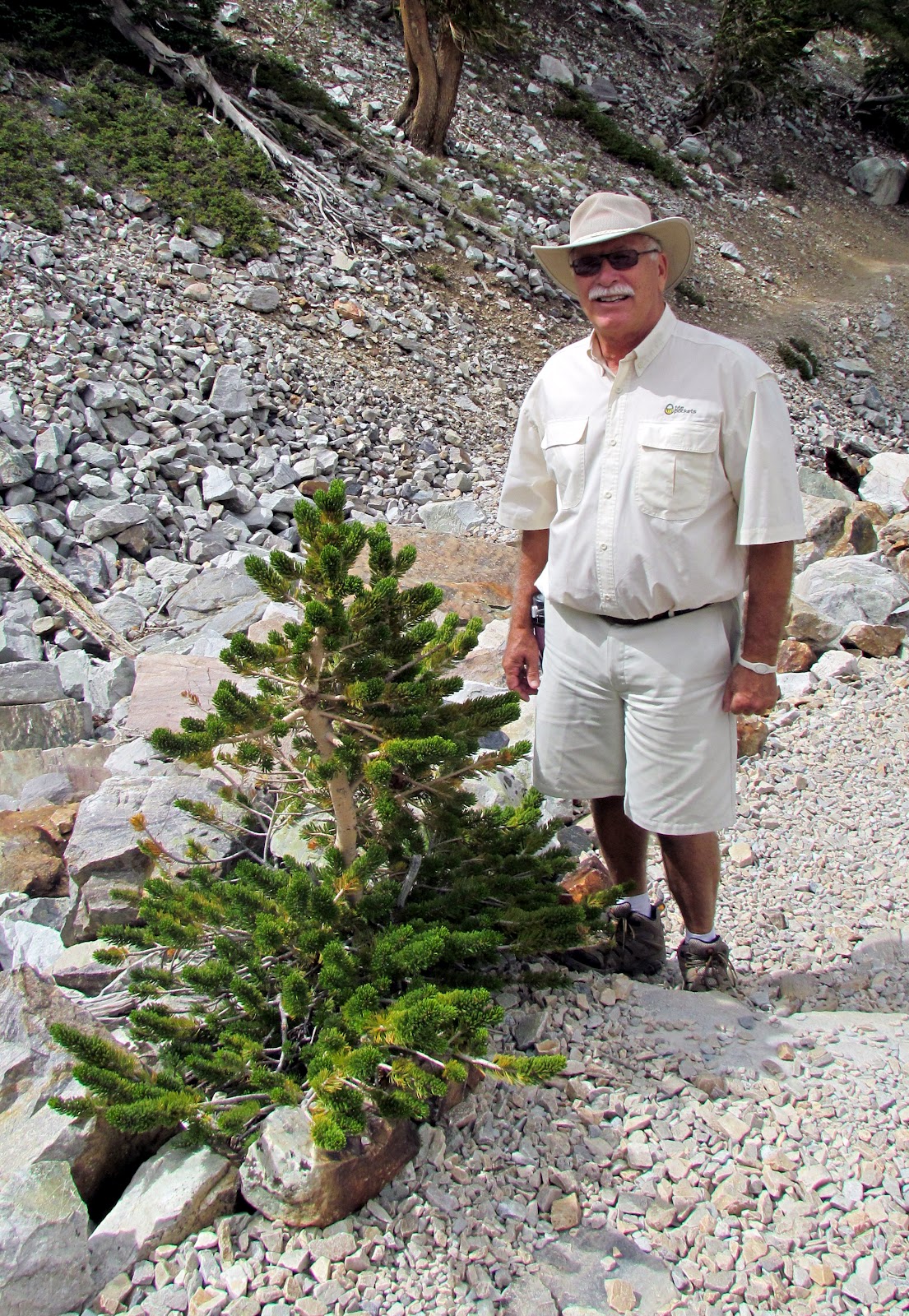
This park actually has two separate sections- the higher elevations including Wheeler Peak, which at 13,063 feet, is the second-highest peak in Nevada- and the Lehman Caves.  Dale and I had decided to come to this park for one reason only- to see the oldest living organisms on earth.  These "organisms" are Bristlecone Pine trees, found in only a few locations in the world, and always at high elevation in an environment of harsh wind, cold, and few nutrients.  In this environment, these trees grow extremely slowly, their wood so dense it is resistant to insects and rot.  By the time they reach old age, they often only have a few strips of bark left to sustain them.  When they die- at ages ranging from 2000 to 3000 years, and sometimes longer- they erode away from ice, wind and rain rather than rot, often remaining standing for another 1000 years.  Their needles can live up to 40 years.  Unfortunately, before the area became a park in 1986, one of the older documented trees, named Prometheus, was actually cut down to determine its age!  It turned out to be in excess of 5000 years old!  Now, instead of cutting down trees to determine age, they use a borer to take a core sample of the tree, which allows them to count the rings without damaging the tree.

We stopped in the Visitor Center on our arrival, and determined that it was reasonable for us to drive up the 12 mile scenic road, which starts at about 6,800 feet, and ends at the campground, which is at 10,000 feet, then hike to see the trees.  It is here that the 3 mile round trip trail, the Bristlecone-Glacier Trail, begins.  The trail climbs about 600 feet in elevation over wooded paths, with the last 1/2 mile or so over rugged, loose rocks.  We had some concerns due to the high elevation, but we had been over 4000 feet in elevation (other than Las Vegas and St. George) for the past 2 weeks, so figured we were pretty much acclimated to higher elevation.   There is a self-guided loop that takes you through a stand of Bristlecones, with signs to provide information about the individual tree, as well as general information.  Interestingly, the trees growing at the very edge of where they survive often live the longest.  They grow the slowest, and are therefore more resistant to the things that can kill them!  We did spot several small trees, but it is questionable, because of climate change, if these trees will survive as long in the future.  It was certainly worth it to make the 2 1/2 hour climb to see these rare trees!

On completing the scenic drive, we decided to check with the Lehman Caves Visitor Center to see what tours were available.  Unfortunately, it being after 4pm, all the tours had ended.  We discussed returning the next day, but our lodging was over an hour away- Great Basin is very isolated- and it would be coming back in the wrong direction for our next destination.  We decided to opt out of the caves.  By the way, the Great Basin National Park came up earlier in our trip when we learned about the "dark sky" issue- it is one of the darkest locations in the continental United States.  Guess the best way to see the stars would be to camp there, as I would not want to drive over an hour through the empty, desolate desert at night!

At treeline

Our first Bristlecone

Bristlecone number 2

Another Bristlecone Pine

Butterfly along the trail

Live Bristlecone

Mule deer

The next generation

On the trail- note the drop-off

The trail up...

View of the glacier on Wheeler Point

View of Wheeler Point at 13,063 feet
We left the park to drive to Ely, over an hour away, where we will spend the night.  On the way out of the park, we saw several mule deer grazing, one of whom could have cared less that we wanted his picture.  We planned to drive to Salt Lake City the next morning.

Thursday, August 9, 2012

Las Vegas, Hoover Dam, and St. George

August 1st-4th

After driving several hours from Capitol Reef, we spent the night in Cedar City.  They had also had recent flash floods.  We ran into some muddy water over the roads when driving to get dinner.  One special thing about the restaurant where we ate- hummingbirds!  Lots and lots of hummingbirds, at least several varieties.  The restaurant had several feeders hanging outside the windows.  It was great entertainment.

We were able to contact Tim, my nephew, and made arrangements to meet with them for dinner on Friday night.  That having been decided, we decided to go on to spend the night in Henderson, NV, just outside Las Vegas.  We drove in, visiting the Fremont Experience, which was pretty crazy.  We ate lunch, then returned to the hotel, intending to visit The Strip that evening.  We began to discuss Kate and Tim's schedule and realized, according to their last blog, they were going to Las Vegas.  Since that was several days previously, we thought they would have left, but they had decided to stay a few extra days.  They were camping about 4 miles from our hotel.  We drove over to meet them, than went in to Vegas, where we spent time wandering around the Venetian.  What a spectacular building!  We watched the indoor gondolas, watched some of the entertainment, than went to dinner.  What a fun evening!  It was great that Tim and Kate had already been in, and had great ideas about what to do.

On our way back to St. George, UT, the next morning, we drove out to Hoover Dam.  We had visited the dam in 2009, so we decided not to tour this time.  Our primary reason to visit was to see the completed bridge over the ravine just below the dam,which was under construction on our last visit.  It looks great, and eliminates the need for all travelers between this part of Nevada and Arizona of having to travel over the dam with its security checks.  I'm sure that has improved travel significantly.

Back in St. George, we met with Tim, Jenn, Lexie and Austin at the Anasazi Steak House.  It was a great restaurant, with a unique twist.  You could opt to "cook you own"- they would bring you your meat just seared along with a "stone", an 800 degree hot surface on which you cooked your meal.  The food was excellent.  It turns out Lexie was an expert on this place, as she works there.

New bridge at Hoover Dam

View of Lake Mead
Everyone looked great.  Lexie is turning into a beautiful, very athletic young lady who loves rugby.  Austin is growing fast, and proud of how tall he is now.  Jenn is working hard, trying to decide whether or not to change jobs, and Tim is working, but dreaming of a change.  It was wonderful seeing them, they are a really nice family.  Unfortunately, I did not get pictures this time.  After a great evening, Dale and I made plans to drive up to Great Basin National Park in the morning.

Wednesday, August 8, 2012

Capital Reef National Park

July 31st and August 1st

We drove west through the western desert of Utah, then headed south to Capital Reef.  We arrived early enough in the day that we decided to go to to the Visitor Center to see how we should spend our time the next day.  On route, we drove by our motel, located in the small town of Gaineville.  Turns out, I think our hotel WAS the town!  There was nothing else around so, we decided if we wanted to eat that night, we would need to drive to the other side of the park to the small- but bigger- town of Torrey, so a visit to the Visitor Center would be on our way.

 Capital Reef is a long, narrow park, oriented north to south.  It was established to protect one of the largest of geologic features known as "monoclines" in North America in  1971.  I'm not sure how many of the 750,000 visitors a year care about that, except that it creates a place of dramatic beauty.   According to the National Parks book, the nearest traffic light is 78 miles away.   Route 24 actually goes right through the middle of the park, which is only about 12 miles wide from east to west.  We were immediately impressed with the rock formations and noted the raging, red Fremont River traveling next to the road.  It was obvious it had rained recently and heavily in the park.  This time of year is Monsoon season in the southwest.  We had intermittently been sprinkled on and seen storms in the distance over the past week or so.  This was the most evidence of recent rain we had seen.

We stopped in the Visitor Center and were told we still had time to take the Scenic Drive, which started just beyond the center.  The ranger warned us, however, that they had recent flash floods, so to be careful if we went into any of the gorges on the trip.  As we traveled the beautiful road, admiring the many rock formations, we noted signs saying not to park in the washes (low spots in the road), as flash flooding could cause problems.  When we reached the end of the paved road, there was a dirt road into Capital Gorge, a two mile canyon leading down to the Fremont River.  We decided to drive in a short distance to see what it looked like.  The steep cliffs hung over us as we drove, and we noted large rocks that had obviously tumbled from the cliffs above.  It was a little concerning, but just beautiful.  We continued in about a mile and a half, and decided to turn around.  It was the best part of the scenic drive!

We continued west on Rt. 24 to Torrey, looking for something to eat.  We saw a small pizza place with outdoor seating.  The view was of the parks' red rocks.  The pizza was great, but even nicer, they had entertainment.  The young man played a combination of violin (fiddle) and piano.  He had bells on one ankle and what appeared to be shells on the other ankle that made a  "clacking" sound when he tapped his foot.  His voice wasn't great, but he was a great musician.  Turns out he graduated from the New England Conservatory of Music, and had been traveling around for several years since, living in Alaska, Washington state, and had been in Utah for about 5 years.  As he was singing, we saw a rainbow over the mountains.  On the drive back to the hotel through the park, we spotted another rainbow.  We drove to an outlook and I ended up running up a hill, camera in hand and two slices of pizza and a beer jogging in my stomach, to get to the top before the rainbow disappeared.  Almost made it, caught the end of the rainbow!  A great evening!

The next morning, we again drove in from the east, stopping at the orchards to pick peaches.  Many years ago, the Mormons settled this valley, and planted numerous fruit orchards, including apple, peach and pear.  Many of the trees still remain, and visitors are allowed to "u-pick" the fruit for a small fee when it is ripe.  The peaches were delicious!  Our next stop was Hickman's Bridge, which is actually an arch.  We hiked in the 3 miles round trip to the bridge, which was nice, but certainly not as impressive as some of the arches we had recently seen.  However, we did see a lot on the hike in, including a "waterpocket".  These are simply hollows in the rock that collect water when it rains.  Frogs will lay eggs in the "pocket", and the eggs must hatch to form tadpoles, the tadpoles must develop into frogs, all before the water dries up!  This is usually about 2 weeks.  When it rains, the process starts again.  We also saw a few areas of rock obviously shaped by water, with smooth grains and beautiful apricot color.

View on Scenic Drive

Capitol Dome

View of wall in Capitol Gorge

Rainbow over Capital Reef

Driving in from east entrance

Road into Capitol Gorge

Water on rock...

Hickman's Bridge

Navaho Dome

Petroglyphs

The raging Fremont River

The orchards of the Mormons

Red rock
We stopped to view the petroglyphs left behind by the Fremont Indians who inhabited this area long before the Mormons.  Many of the pictures represented strange triangular people and animals that were common in the area.  After another stop at the Visitor Center to watch the movie, we went to the picnic area for lunch and realized we were very close to being rained out.  The sky was dark, and thunder was heard in the distance- the end of a great visit to a really under-valued park.  We headed west, then south, toward St. George.