Sunday, August 5, 2012

Grand Junction- Black Canyon of the Gunnison National Park

July 30th

On Monday morning we set out in Larry's truck to find the Black Canyon of the Gunnison.  After a few wrong turns, we entered the park via Black Canyon Road to the North Rim.  Apparently, this is not the usual entrance.  The road in is dirt, and so is the road that follows the canyon and overlooks.  Looking across the canyon, you could see the South Rim, with its paved surface.

 It really didn't matter.  The national parks brochure describes the Canyon as "an awesome gorge", and it is- no matter which rim you view it from!  As we reached each overlook, Dale would hurry to the viewpoint and call back- "Wow, you have to see this.  This is amazing!"  My sister and I always reached the overlook slowly, just to make sure we didn't fall over the edge, I guess.  Although there was good fencing in place, it was a little nerve-wracking to peer straight down into this steep, deep, narrow gorge.  As one geologist wrote "... no other canyon in North America combines the depth, narrowness, sheerness and somber countenance of the Black Canyon of the Gunnison."  It was named "black", as very little light can penetrate the bottom.

The canyon has limited travel for humans in this area for centuries.  No humans have ever occupied the gorge, only the rims.  In 1901, Abraham Lincoln Fellows and William Torrence floated into the river on a rubber mattress covering 33 miles in 9 days, to survey the river for a possible source of irrigation water.  The park was declared a national monument in 1933, and was made a national park in 1999.  The park contains 14 miles of the canyon's 48 mile length.  In its 48 mile length, the river loses more elevation than the entire 1500 mile length of the Mississippi River does from Minnesota to the Gulf of Mexico.  The Gunnison drops an average of 96 feet per mile in the national park.  The rapid fall accounts for the steepness of the canyon- the walls are carved deep rather than wide.

After completing the access road to its end, we turned around and continued the way we came.  We stopped at a ranger station, and the ranger suggested we walk a nearby nature trail that leads to a view of Exclamation Point, one of the highest points of the rim, 2700 feet over the river.  The walk through the woods was pleasant, and the view very much worth it.  A great park to visit.

We left the park, and continued further south to see the Blue Mesa reservoir.  This is a very large reservoir that is used not only for water, but for recreational boating and swimming.  It was very obvious by looking at the old water levels that it has been heavily impacted by the drought.  It will take years of good rain to refill a reservoir so large!

Blue Mesa Reservoir

Exclamation Point

Linda and Larry at the Black Canyon

The Steep, Deep, Dark Canyon

The Narrows

View of the Gunnison River
We enjoyed dinner on our way back to Grand  Junction.  Tuesday morning we hung out, packed and talked.  After lunch, Dale and I were on our way back to Utah to see the Capital Reef National Park.

Saturday, August 4, 2012

Grand Junction- Colorado National Monument

July28th and 29th

After retracing our steps on Rt. 70 through the western Utah desert, we arrived in Grand Junction.  Grand Junction's name originates from the fact that the Colorado River and the Gunnison River join in that area.  It is a fairly large town, about 80,000 residents, and has managed to keep the central portion of the city vibrant.  In addition, it is a college town, which always seems to bring a certain energy to a city.  Grand Junction is defined not only by the rivers, but by its mountains.  To the east is the Grand Mesa, which is the largest flat-topped mountain in the world.  The front windows of my sister's house face the Bookcliffs, which are a range of mountains that supposedly look like books on a shelf.  To the west is the Colorado National Monument, an area of deep canyons, red rocks, and high plateaus.

We spent Saturday evening catching up with my sister Linda, her husband Larry, and her son Jon. On Sunday, we decided to head out early- it had been hot and unusually humid for this high desert area- to re-explore Colorado National Monument.  The Monument was dedicated by President Taft 101 years ago, in 1911.  The Rim Rock Road, the major means of accessing the park, was built in the 1930's.  The 20 mile road traverses a plateau which rises 2000 feet over the fertile valley below- the Grand Valley of the Colorado River.  It is part of the same Colorado Plateau that we know incorporates many other national parks, including Arches and Grand Canyon.  In actuality, this 32 square mile park is being promoted by many for inclusion as a national park.  A man by the name of John Otto first recognized this area as needing protection.  In 1907, he began encouraging it to be protected as a national park.  It was made a monument, but perhaps the time has come to increase the protection of this dramatic landscape.

We drove the 20 mile road, stopping at many of the overlooks to view the deep canyons leading to views of the valley, the Grand Mesa, and the Bookcliffs.  One of the overlooks features rock monoliths called the Coke Ovens, as they resemble the ovens used to make coke from coal.  They are formed by the sculpting forces of wind, water and ice.  Another viewpoint is of Independence Monument.  This rock structure was once part of the canyon wall.  It separated, and has been eroded to how it now appears.  This structure will look familiar to many of you, as it has been used in multiple advertising campaigns, usually with a car on some variety on the top.  As we were driving, we kept watch for Golden Eagles, which are common up here.  I have viewed many on previous trips, but unfortunately, none today.

Balanced Rock

Independence Monument

Red Canyon Overlook

The Coke Ovens
We stopped at the Visitor Center and were pleased to see that it has been recently updated.  The displays have been refurbished, and it looks more than ready to take its place as a national park.  We returned to Grand Junction, with plans to drive Larry's new truck south to the Black Canyon of the Gunnison on Monday.

Thursday, August 2, 2012

Canyonlands National Park

July 27th- afternoon

Canyonlands National Park is divided into three distinct sections by the Green and Colorado Rivers- Island in the Sky, Needles and The Maze.  Island in the Sky is an easy 30 mile drive from Arches.  After completing our hike to Delicate Arch in Arches, we decided to spend the remainder of the day in Canyonlands.  The Island in the Sky section is a high mesa, rising 2000 feet above where the Green and Colorado rivers join.  On entering the park, we decided to drive out to the furthest point, Grand View Point, in order to get a bird's eye view of the rivers and of Monument Basin, where you can see stone columns and deep canyons carved by the rivers.

When we arrived, one of the rangers was giving a talk on the geology of the view below.  It was amazing to realize that this area has been inundated by ocean at least 29 times in the past, prior to the elevation of the Colorado Plateau when tectonic plates collided and caused the area to rise.  Below, you could identify what used to be sand dunes and white salty areas that were most likely the shoreline of the ancient ocean.  Once the plateau rose, the rivers carved deep canyons into the soft stone.  The resulting view was dramatic, with deep canyons, the view extending out about 100 miles.  The ranger pointed out the location of Needles and the Maze.  Needles was at least 3 hours away by car and roads into the area are minimal. However, it was only 12 miles across the canyon! The Maze is the most isolated area, with the most common means of exploration on foot.

After the talk and enjoying the view from Grand View Point, we drove back toward the entrance, stopping at a number of overlooks.  The view from Buck Canyon overlook was particularly beautiful, with great views of the Green River.  We stopped at the trailhead for Upheaval Dome and walked the 1/2 mile trail to view this geological feature that appears to be a crater, about 1 mile in width, closed in by concentric circles of rock with a center rock spire.  There are several theories regarding its origin, including a large meteor strike.

View from Grand View

View from Grand View

View from Grand View

Spire in the Monument Basin

View from Dead Horse Point

The two of us in front of Mesa Arch
Our final stop was at the trailhead for Mesa Arch, a much-photographed arch that I had always assumed was in Arches National Park.  The 1/2 mile walk took us to the arch, which frames a beautiful view of the La Sal mountains.  After resting and photographing the arch, we headed back to Moab for a much-deserved swim in the pool.  We did make one more stop- we had been told that the view from Dead Horse Point in Dead Horse Point State Park, adjacent to Canyonlands, was a "must see".  We drove in, and the view of the Colorado River was truly spectacular.  After visiting Arches again Saturday morning, we will head to Grand Junction, CO, to visit my sister and her family for a few days.

Wednesday, August 1, 2012

Arches National Park

July 27th and 28th

We decided to take the advice of the Visitor Center person regarding seeing Arches in the mornings and saving Canyonlands for afternoon.  However, we did not take her advice regarding hiking in to see Delicate Arch, which is one of the well-known arches in the park.  The hike in was 3 miles round trip, with a moderate elevation change, the most difficult portion on ledge.  However, preparation is everything- water, hat, sunglasses, sunscreen, and walking shoes- all set!  We were on the trail by 7:45am, the temperature was 81 and it was sunny.  We did not have much difficulty, although I was a little concerned by descriptions of the last portion of the trail, which was on a narrow ledge.  I was picturing a 2 foot wide ledge with a steep drop on one side and a wall on the other.  When we reached that area, the ledge was wider than a city sidewalk.  However, there was a steep drop and there was a wall on one side.

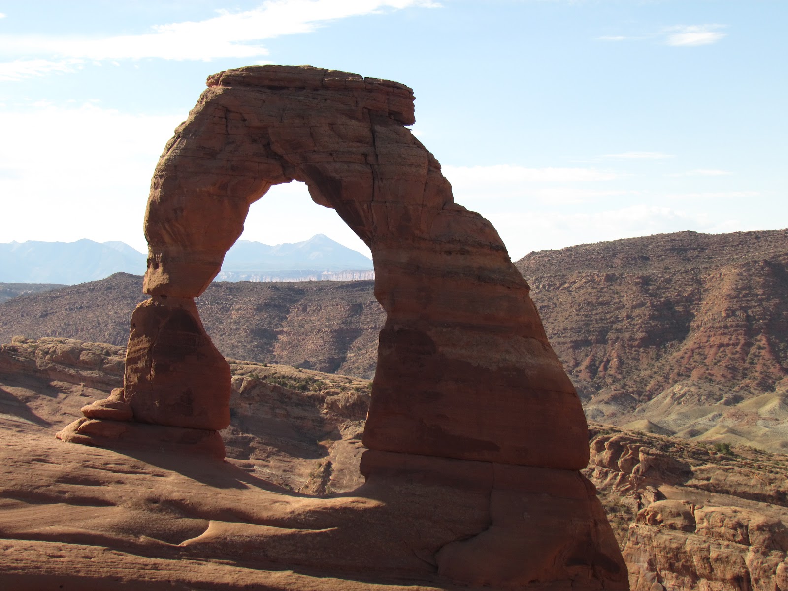
The close view of Delicate Arch was really worth the hike.  It is out there by itself, with one side (or leg) looking as if it could collapse at any moment.  It took us about 2 hours for the round-trip hike.  We took a side trail at the end to view some petroglyphs.  We were back in the car at 10 am, the temperature was up to 88.  It was a smart idea to hike early!

The next morning, we were on the trail to Landscape Arch at 8:15am.  The temperature was a wonderful 72 degrees with a nice breeze. The trail to Landscape Arch, another of the iconic arches in the park, was about one and one half miles round trip.  The arch, at 308 feet from base to base, is the longest known freestanding arch in the world.  The trail was pretty easy, primarily gravel path with only a very minor elevation change.  The arch was spectacular to see.  One end was very thin, appearing as if it could fall at any moment.  As a matter of fact, in 1991 it came close to it.  Hikers were sitting under the arch and saw some gravel and sand falling from the arch, followed by cracking and popping noises.  As they scrambled from underneath the span, a 65 foot piece suddenly broke off and fell to the ground.  There area is now fenced, and visitors are no longer allowed under the arch.  I'm just glad it was still there for us to see!

The Gossips

Delicate Arch

Pictographs

Yikes!
Landscape Arch
We returned to our vehicle and continued to tour the park.  We walked in to see Sand Dune arch, trudging through soft sand on our way through the fins.  We then drove down to see Double Arch and walked a mile round trip to see the North and South Window, as well as Turret Arch.  This park was truly spectacular.  Although several of the well-known arches require some walking, much of the beauty of this area can be appreciated by anyone from the viewpoints and from the road, so add it to your list!

Steamboat to Moab

July 26th

We left Steamboat Springs on Thursday morning, heading west on route 40 towards Craig, CO.  This was designated as a scenic drive, and it was beautiful- rolling green hills, dotted with scattered cattle and horse ranches.  The Yampa River followed the route most of the way, so the reason for all the green in the middle of this drought was clear.   As we drove further west, we also crossed the White River.  We had planned to head south at Craig, but noticed route 139, which goes north to south just inside the western border of Colorado, was also a scenic route.  Route 139 was scenic, but much different from Route 40.  There were red buttes and rock outcroppings, scattered oil wells, and draws (dry river beds that flood when it rains.)  We stopped for lunch at a recreation area, taking advantage of several nearby trailheads to take a short walk back into one of the canyons.  Way better than McDonalds!

When we arrived at Moab after a 5 hour drive, we headed to the Visitor Center.  This center provides information on all the local sites, including both Arches and Canyonlands National Parks.  We had planned to spend one day in Arches and one in Canyonlands, but she advised us to spend both mornings in Arches and the afternoons in Canyonlands.  Arches is down in the valley, which can become very hot by mid-day.  Canyonlands is 1000 to 2000 feet higher and, therefore, remains cooler later in the day.  We decided that was probably wise.  She also advised us not to hike the trail into Delicate Arch, one of the better known sights in Arches, as it was hot and part of the hike was relatively strenuous.

Oil well pump

View of canyon at rest area

View along CR 139

Another CR 139 view
The Visitor Center holds weekly talks open to the public on different topics of interest.  The talk scheduled for that evening was on light pollution.  It sounded interesting, so Dale and I decided to attend.  Unfortunately, not many others showed up.  The young woman who gave the talk had a background in astronomy.  She previously worked for the Park Service in several locations around the country and gave ranger talks on the night sky.  She currently works for the Department of Natural Resources and helped to start a local chapter of The International Dark-Sky Association.  This group is working to reduce light pollution in order to keep the night sky visible to all, and to prevent some of the recently documented medical issues associated with excessive light.  She indicated that there are many children growing up today that have never seen stars in the night sky due to this problem, and many animals and other natural functions have been negatively impacted by this problem due to changes in circadian rhythm.  The Association works with cities and towns to teach them about safer, less polluting outdoor light fixtures.  Of interest is that these fixtures also save money, as it allows users to use more energy efficient bulbs, as the light is being directed exactly where you need it- not scattered to the sides or up into the atmosphere.  Overall, very interesting and thought-provoking.

Friday, July 27, 2012

Steamboat Springs

July 23-26

Dale and I decided to take a few days off to play golf and relax.  We had been to Steamboat Springs about 5 years ago and enjoyed it, so headed there.  Steamboat Springs is well-known to skiers, both for the quality of the ski runs and its role in the history of establishing ski jumping here in the U.S.  However, unlike many "ski towns", Steamboat existed as part of the western frontier prior to the arrival of the skiers.  As legend has it, the town was named for the numerous springs found in the area, in particular one that made a chugging sound, similar to a steamboat, as it spewed water 15 feet into the air.  Unfortunately, after the railroad was put in, the chugging stopped.  To celebrate the frontier spirit (and to not be outdone by Kate) I purchased a cowboy (girl) hat at F.M.Lights, which has been around selling western gear for over 100 years.

On Wednesday, we played golf at a local public course called Haymaker.  The course was in great shape, though somewhat pricey for a public course, and we enjoyed the round.  As usual, did not play as well as we would have liked, but had fun anyway.  After, we wandered the downtown area.  It has interesting old buildings that are now shops and restaurants, and there are flowers everywhere- hanging pots, barrels, and window boxes.  Several restaurants have outdoor seating, which gives the downtown a friendly, social feeling.

The next day, we decided to explore some of the natural areas surrounding Steamboat.  In spite of the extensive building of condominiums on the sides of every mountain in the vicinity, there are still some places to experience nature.  We drove up to a National Forest recreation area known as Fish Creek Falls.  It became part of the National Forest through the efforts of Bob Adams, who recognized that, unless the area was protected, the general public would be excluded from this beautiful area.  It was a nice walk on paved walkway to view the falls, which is about 285 feet high with a free fall of 60 feet.  There was sufficient water to make the falls really beautiful.  We then walked down to the base of the falls, where a walking bridge spans the river.  The view from the bridge was great.

We then drove to Rotary Park, where we walked a boardwalk into the wetlands and viewed the Yampa River.  The Yampa is a tributary of the Colorado River, and is important to Steamboat as a water source, and as a focal point for many activities.  We walked into town and viewed the springs that are the town's namesake.

Windmill on road to Fish Creek Falls

African Daisies on walk to falls

Fish Creek Falls from overlook

Falls from the bridge

The Yampa River

Yampa River occupants...

Street view of Steamboat Springs

Steamboat Spring
It was a wonderful, relaxing time.  Friday morning we are off to Utah to visit Arches and Canyonlands National Parks.

Wednesday, July 25, 2012

Rocky Mountain National Park

July 22nd

On Sunday we left Laramie and headed towards Estes Park, CO, the gateway to the Rocky Mountains.  We had visited Estes Park about 5 years ago on a trip to visit my sister.  At that time, when we arrived in town, there were herds of elk wandering all over the town, congregating around the Visitor Center in particular.  We were disappointed that we did not see a single elk this time.

Estes Park is a lovely town, bordered by the Big Thompson River.  There is a walkway along the entire river behind many of the shops and restaurants, making a great focal point for socializing.  As you might expect, there is everything from high-end restaurants and art shops to take-out and tee-shirts.  A great little town to explore.

The next morning we headed over the Trail Ridge Parkway, which bisects the park. This road reaches elevations of over 12,000 feet, and is dwarfed by surrounding peaks of over 14,000 feet.  It is billed as the most scenic drive in the country, and I would believe it.  For those of you that have never driven it, add it to your bucket list. I would recommend, for those who might be nervous about driving mountain roads, to drive it east to west (Estes Park to Grand Lake), as it is easier to drive up the steeper east side than down! We had driven this road the last visit, but quickly drove to the Alpine Visitor center just below the highest point of the road, in order to do a ranger-led hike.  As a result, we missed most of the scenery.  I do remember there was much more snow last time, as we were here a month earlier.

The views from the numerous overlooks were spectacular.  We walked out to several viewpoints and were pleased to see several marmots (part of the squirrel family, but much bigger) that live at these high altitudes, hibernating for about 8 months of the year.  The several we saw were pretty fat!  At one of our stopping points, we found quite a few wildflowers.  We had intended to take a short hike at Deer Ridge Junction into several lakes, but there were so many people on the road, there was no where to park at the trail head.  Rocky Mountain National Park is one of the most visited parks, and there is some concern with the amount of pressure all of these visitors cause on wildlife and the delicate terrain in this alpine tundra.  If trampled, tundra plants can take up to a decade to recover.


After crossing over the summit, the drive down the west side is more gradual, but does not have the spectacular scenery seen on the east side.  There are more trees, primarily evergreen, and open marsh land.  We just missed seeing a moose in one of these areas- we knew there had been one by all the vehicles pulled off the road!  The parkway ends near a town called Grand Lake.  We drove in for lunch- what a cute little town!  The sidewalks are all wooden, like you see in old westerns.  The main street has many shops and restaurants, the road parallel to main runs along the lake.  There were lots of folks boating, swimming and hanging out.  It was great weather, and people were really enjoying it.  In this area, the damage done to the Ponderosa Pines by the pine borer beetle is really evident- it appeared that more than 50% of the trees were dead or dying- much higher than we saw 5 years ago.  We ended our day in Steamboat Springs, where we intend to spend a few days to golf and relax.